


ISH Field App

Description of ISH Field App
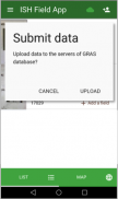
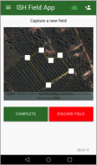
The Smallholder App allows to collect basic data on Independent Smallholders (name, address), take photos and collect the outline of their fields as georeferenced polygons directly onsite. In its full version, the App allows to upload the collected field polygons directly into the ISH Data Management System and in the GRAS Tool and to analyse the fields against sustainability criteria (biodiversity, land use change).
The App allows the collection of several fields' outlines for the same Independent Smallholder and/or for many different Independent Smallholders. The collection can be performed also offline. If the collection is taking place while offline, the upload of Smallholders' data and fields into the ISH Data Management System and GRAS Tool will take place once the device is again online.
The upload of polygons and collected data is only available for users which has registered for ISH certification project with ISCC. For all other users the upload function is not provided.


